
DENVER — THE FORECAST BY: Meteorologist Cory Reppenhagen
FORECAST HEADLINES:
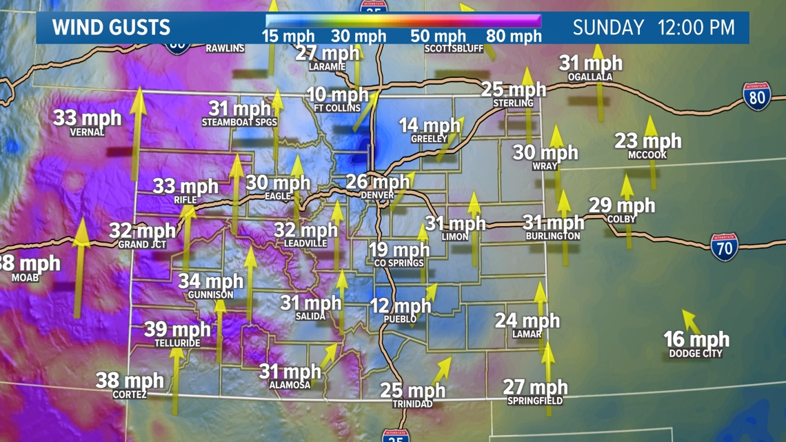
The calm to light winds on the Front Range on Sunday morning will gradually build into the afternoon. Most of the wind gusts in the Denver area should stay in the 20-30 mph range but there is a possibility for a few stronger gusts in the 40-50 mph range.
Those winds could cut into the comfort level some but expect high temperatures to be very warm in the middle to upper 70's.
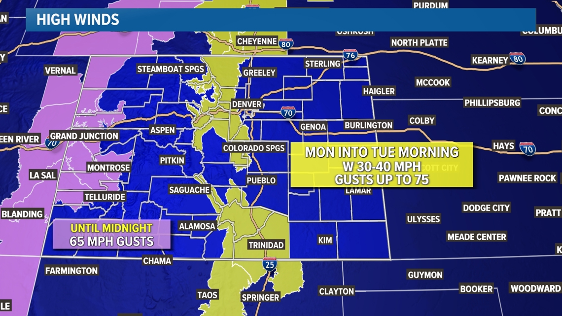
Winds will remain the focus of attention going into Monday as nuisance winds could turn into damaging winds. The mountains and foothills east of the Continental Divide will see a high wind warning issued lasting all day Monday into Tuesday morning with peak wind gusts up to 75 mph possible.
The low-pressure storm system brining in the winds will also bring winter back to the Colorado mountains. Expect scattered afternoon rain showers to develop changing into snow after 6pm.
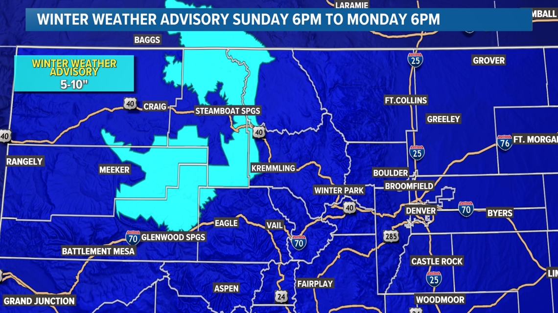
There is a winter weather advisory out for the northern mountains where 5-10 inches of snow will be possible above 8,000ft. Some mountain towns could get 1-4 inches of accumulation.
The cold air will settle into the Front Range by Wednesday morning where the low temperatures are forecast to be down into the middle to low 30's. No frost advisories or freeze warnings are in place yet but those will be a possibility both Wednesday and Thursday morning.
With those cold temps, snow showers will be a possibility in the Denver area, but snow accumulation is unlikely. However, there will be some slight thunderstorm or rain shower possibilities in the Denver area Wednesday through Sunday. At this point no widespread heavy rain is anticipated.
Fire Weather
Wildfire danger is elevated anywhere with windy conditions present, but there are a few areas with a fire weather warning where those winds combine with humidity as low as 7%. Those warned areas include the San Luis Valley, parts of the Sangre de Cristo range, and the southeastern plains.
Fire weather is forecast to be elevated through Tuesday.

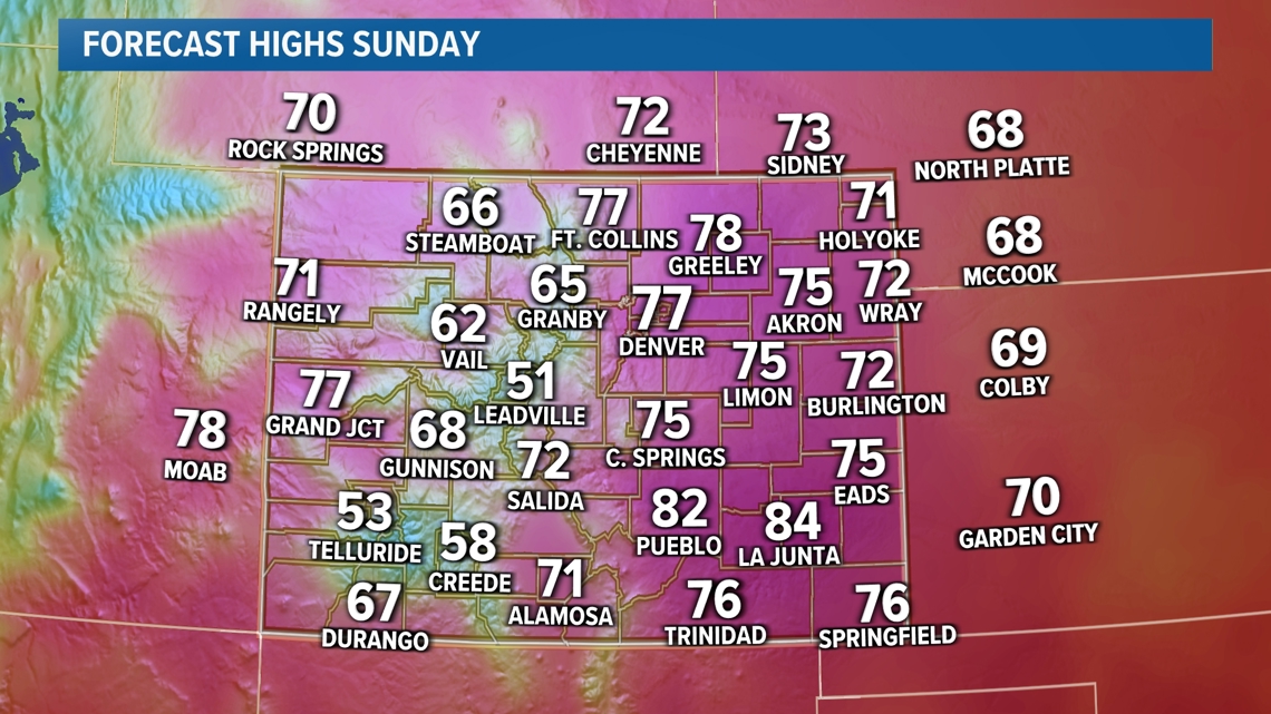


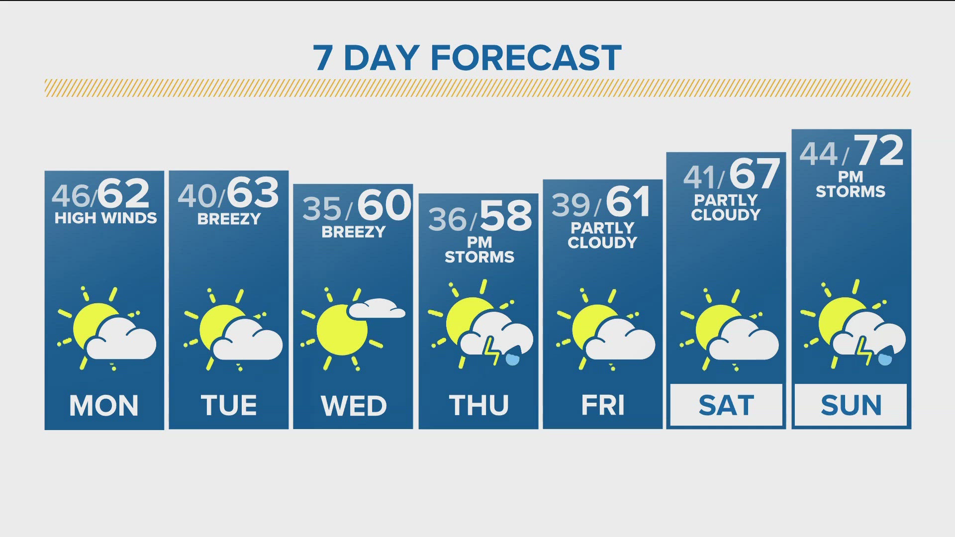
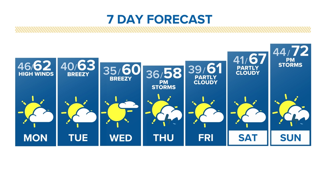
SUNDAY: Partly cloudy and very warm and windy, high 77; mostly cloudy overnight, low 46.
MONDAY: Partly sunny, windy and cooler, with scattered mountain snow showers, high 63; partly cloudy overnight, low 40.
TUESDAY: Partly cloudy, windy and seasonal, high 63; mostly clear overnight, low 35.
WEDNESDAY: Mostly sunny, breezy and mild, high 60; mostly clear overnight, low 36.
THURSDAY: Increasing clouds and late-day scattered showers and a few storms, high 58; cloudy, with scattered showers overnight, low 39.
FRIDAY: Mostly cloudy, with an isolated shower, high 61; cloudy, with scattered showers overnight, low 40.
SATURDAY: Partly cloudy, with isolated showers, high 67; partly cloudy overnight, low 41.
SUNDAY: Mostly cloudy with a chance for showers and storms, high 72; mostly cloudy overnight, low 44.

CLOSINGS: Latest closings and delays in Colorado
WEATHER LINE 9: Updated weather forecast information at 303-871-1492.
SUGGESTED VIDEOS: Denver March Snowstorm 2024
TRAFFIC CENTER: Keep up on crashes and travel times here
If you have a weather report, photo or video to share, you can contact the 9NEWS Weather Team in these ways:
EMAIL: Weather photos, videos
Share updates on our Facebook wall: facebook.com/9weather
Tweet your updates using the hashtag #9WX or tweet us at twitter.com/9NEWSWeather
Download the 9NEWS app:
iTunes: on9news.tv/itunes
Google Play: on9news.tv/1lWnC5n
The 9NEWS Weather team of Kathy Sabine, Cory Reppenhagen, Laurann Robinson, Keely Chalmers, Ed Greene and Chris Bianchi update the Denver weather forecast multiple times each day. Bookmark this link to always have the latest forecast from 9NEWS. The team values your local weather reports and often features your photos and videos during weather segments in all newscasts.
SUGGESTED VIDEOS: Science is Cool